
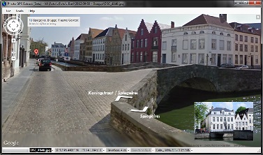
Photo GPS Extract can be setup so it immediately jumps to Google Streetview when opening a photo. Then you get to see a 360° panorama of the location where your picture was taken (if available).
Markers for nearby pictures will also be visible in the panorama, they allow you to jump between photos by just clicking the marker.
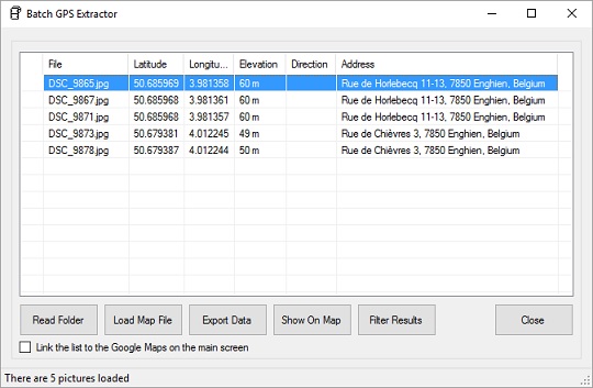
The Batch Extractor is a powerful tool to extract the GPS coordinates from a large amount of pictures. Optionally, it can automatically lookup the street address for each one of the pictures.
Once the batch extractor is finished processing all files, you can choose to show the data on a map. You can also export it to a file, like a customizable CSV file (Comma Separated Values). There are also other possible exporting formats like GPX (GPS tracklog), KML (Google Earth), HTML (Web Page), ...
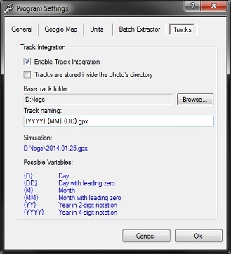
PGE can instantly locate the GPX track that belongs to a certain photo. This function is interesting for people who are using a separate GPS unit to log their tracks:
Using my portable outdoor GPS I keep logs for all trips I take. These logs are stored as GPX files (an XML-based file that contains the complete path I walked). I usually store these GPX files into a single folder on my computer and name them by date (like D:\logs\2014.01.25.gpx).
When the integrated GPS-track function is enabled, you can open the track for a JPG file by simply clicking the menu "Tools" > "Open Track Log For File". PGE will determine the correct track log by reading the picture's date, and then open the corresponding log in its default application. This function is quite flexible: you can select the log folder and specify how these files are named.
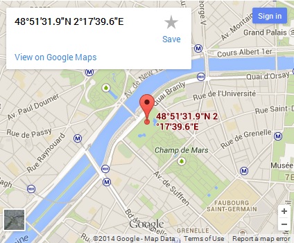
Photo GPS Extract can generate the HTML code to build your own embedded Google Map. This map can then be integrated in your website or BLOG. The following dialog was used to create the Google Maps below:
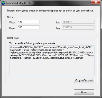
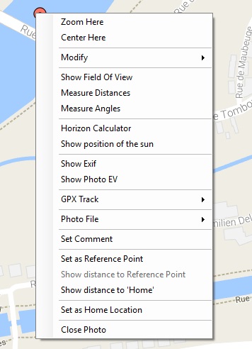
Each photo location is indicated as a marker on the Google Maps. You can right-click these markers to open a context-menu which offers you a lot of interesting options.
Photo GPS Extract allows you to export the data from the loaded photos in various ways:
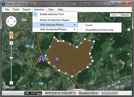
You can use the selection tool to select certain markers/pictures by their location. You could use this feature to select all photos that were taken in a very specific location, like a forest. You then can perform some actions on the current selection, like copying the corresponding pictures to a certain folder.

You can visualize the horizontal field of view (FOV), the triangular area that your camera lens covers. The angle depends on the focal length of your lens. A smaller focal length means a wider field of view. If your photo contains some orientation information (bearing, 0...360 degrees), the displayed FOV will use the same orientation. So what you see on the photo should correspond with what you see on the map.
Unfortunately, many photos will not contain the required bearing-information as this requires the camera to have a built-in compass. In these cases you can set the direction manually. Either by guessing or by using the 'Angular Measuring Tool'

The angular measuring tool allows you to measure angles between two custom lines. You can set these lines yourself by clicking the desired position within the displayed FOV.
One extremely useful feature is that the displayed lines will also be displayed in the 'preview image' box. It helps you to locate visual elements from the photo on the map, and vice versa. This feature also allows you to correct the bearing for a photo. All you need is a fixed landmark on the photo, which must also visible on the map. Photo GPS Extract will then be able to calculate the difference between them, and calculate the required offset to correct the bearing of the photo.
The distance measuring tool is very similar to the angular measuring tool, but it is used to measure distances between two points. You can set these points yourself. The corresponding positions will also be displayed on the preview image.
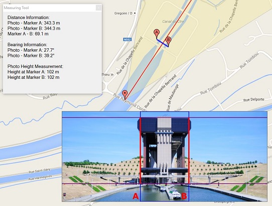
Actually, Photo GPS Extract is also able to measure the physical height of objects on your photos. You just need to mark the location of the object to be measured. This allows the program to calculate the distance between you and the object. Next, you need to mark the vertical starting & ending point of the object in the preview image. I have tested the tool on some objects with known heights and found the results are surprisingly good. I wrote a detailed article on how to use this function.
The following image shows a demonstration on the boat lift of Strephy. According to the measurements, the building has an elevation of 102 meters. In reality the building is 103 meters high, so the result is quite good.
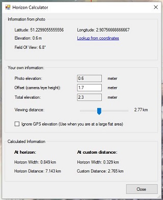
This feature allows you to calculate the distance to the horizon. This distance depends on your altitude: the higher you are, the further you can see. This tool will read the altitude from your photo, and then calculate the distance to the horizon. Of course, this tool assumes excellent weather conditions (clear view).

The new Photo GPS Extract is capable to visualize a GPX tracklog on the map. It will automatically determine the tracklog that belongs to the current photo.
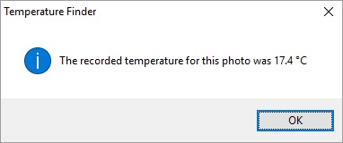
This function can find out the temperature at the time a photo was taken. It does this by examining the GPX tracklog that belongs to the photo. So, you need to have a GPX tracklog and the tracklog needs to have some temperature data.
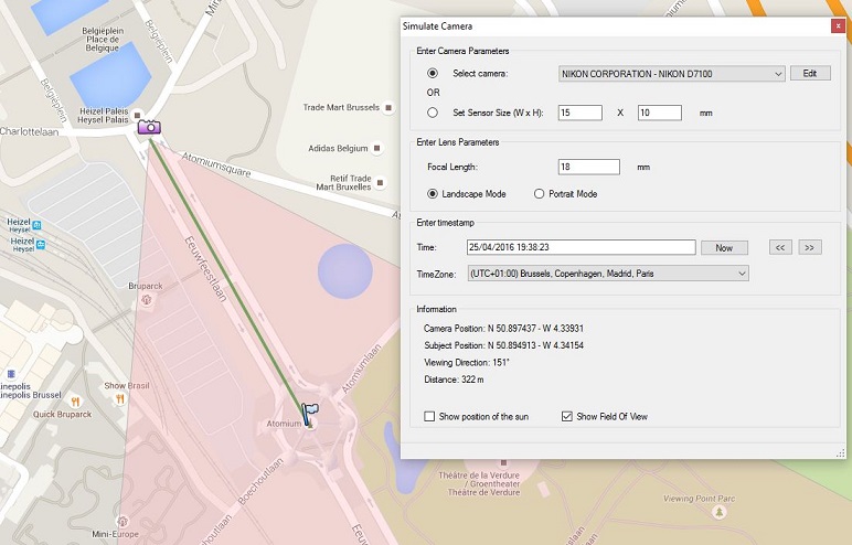
Photo GPS Extract can run a camera simulation: you can select the location of the camera and subject on the map. The program will then tell you the displayed field of view and optionally the position of the sun. It can help you to make preparations for a certain photoshoot.
Later this year (2017) I am planning a new version of Photo GPS Extract that has some even more advanced features. I would also like to increase the performance by switching to another Exif-processor.